The following information is from the National Weather Service as of 11 a.m., Monday, May 22, 2023:
A Typhoon Warning is now in effect for Guam and Rota.
“This means that typhoon conditions are now expected in Guam and Rota,” Landon Aydlett, NWS Guam chief meteorologist said in a presentation early this afternoon.
A Tropical Storm Warning is in effect for Saipan and Tinian.
“The current track has been favoring passage somewhere in the Rota channel,” Mr. Aydlett said. “That track has been shifting gradually to the left. So that brings the track closer to Guam, and farther away from Tinian and Saipan.”
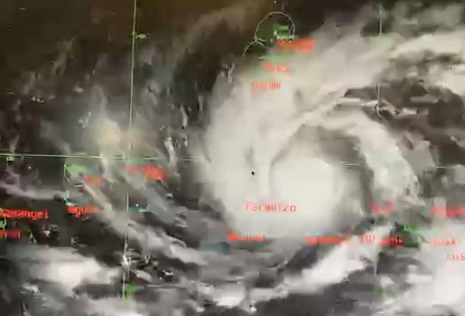
At 10 AM ChST…the center of Typhoon Mawar (02W) was located near latitude 9.0N…longitude 147.3E. This was about 355 miles south- southeast of Guam. Storm motion was north-northwest. Storm intensity was 85 mph.
For those under a warning, now is the time to rush to completion preparations for the protection of life and property. Stay calm and keep informed. Comply with any evacuation orders that are issued for your area. If your home is vulnerable to high winds, or you live in a surge zone or any location prone to flooding, evacuate to a designated shelter or ride out the storm in the sturdy home of family or friends outside of evacuation zones. Items to bring to a shelter include a first aid kit, medicines and prescriptions, baby food and diapers, games and books, toiletries, a battery powered radio, a cell phone, flashlights with extra batteries, a blanket or sleeping bag for each person, personal identification, copies of key papers such as insurance policies, available cash and credit cards.
Remember, pets are not allowed in most public shelters, so check ahead with your intended shelter. Regarding your home or business, cover all windows and doors with shutters or plywood. Move patio furniture and other loose objects indoors. Brace all exterior doors, including garage doors. Do this as early as possible. If you need to make a trip to the hardware store, the grocery store, or the gas station, do so today, Monday.
Probability of tropical storm/typhoon conditions
The onset of tropical storm conditions could start as early as Tuesday morning. The most likely onset of tropical storm conditions is Tuesday afternoon to evening. The onset of typhoon conditions could start as early as Tuesday night.
Winds
As Typhoon Mawar (02W) moves closer, the threat for sustained high winds will increase. The latest forecast is for typhoon force winds on Wednesday. Tropical storm force winds are currently forecast to begin affecting the area Tuesday evening.
Storm surge and surf information
Storm surge of 3 to 6 feet above high tide is expected as Mawar moves overhead on Wednesday. Dangerous surf of 15 to 25 feet is likely initially along south and east facing reefs. Hazardous surf is likely to spread to west facing reefs Thursday or Friday as Mawar moves into the Philippine Sea.
Inland flooding
A Flood Watch is in effect for the entire area. See latest forecast for latest information. Listen for possible flood warnings for your location and be ready to act if flooding rains occur. Heavy rainfall is likely to develop late tonight through the next few days. Rainfall amounts of 9 to 15 inches are possible with locally heavier amounts. Monitor conditions for possible flood advisories or warnings.