This just in from the National Weather Service:
Bolaven now is a typhoon, and its latest track will favor a passage closer to Rota, according to information received at 12:20 p.m. from the National Weather Service Guam office.
—–
From the National Weather Service Guam office at 11 a.m.:
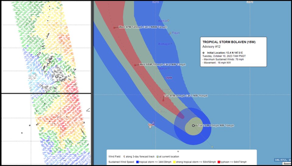
Tropical Storm Bolaven continues a steady, but slow, intensification trend as it nears the Mariana Islands. As of 11:00 AM, Bolaven remained a tropical storm with maximum sustained winds of 70 mph. Bolaven is expected to intensify further, likely becoming a typhoon (74+ mph) this afternoon as it makes its final approach to the CNMI. We just released the 11:00 AM Intermediate Advisory #12A, however, the graphic below reflects the 8:00 AM Advisory #12 information, and forecast track on Page 2. Advisory #13 will be posted online by 2:00 PM, complete with new forecast track and intensity graphics.
In the 11:00 AM Advisory #12A, Tropical Storm Bolaven was located 80 miles east-southeast of Rota, 95 miles south- southeast of Tinian, 100 miles south-southeast of Saipan and 110 miles east of Guam near 13.8N 146.4E moving northwest at 13 mph. Maximum sustained winds were 70 mph. As currently forecast, Bolaven is expected to pass somewhere between Rota and Tinian this afternoon. Any southward shift would bring peak storm winds closer to, or over, Rota; and any northward shift would bring peak storm winds closer to, or over Tinian and Saipan. At this time, Bolaven is likely to pass through the CNMI as a Category-1 (74-95 mph) typhoon.
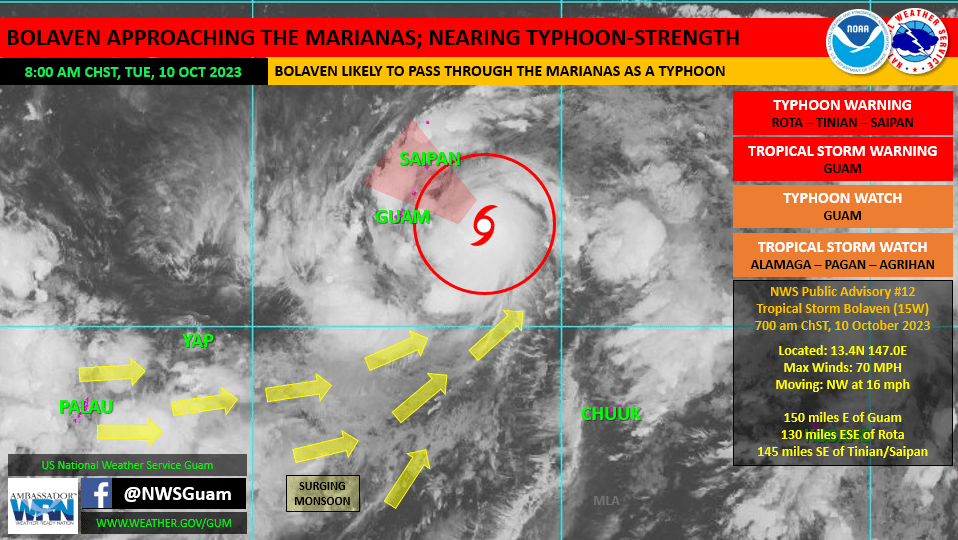
WATCHES, WARNINGS, AND FORECAST IMPACTS:
GUAM/CNMI: All islands will feel the passage of Bolaven, but those closest to the center of Bolaven will feel the strongest winds. Typhoon Warnings remain in effect for Rota, Tinian and Saipan. Tropical storm force winds of 39 mph or more are imminent, building up to typhoon force early this afternoon. A Tropical Storm Warning remains in effect for Guam. Damaging winds of 39 mph or more are imminent and will continue through this evening. Those in the Marianas should stay in safe shelter. Peak weather conditions will be ongoing soon and persist through the afternoon and evening hours.