

Tropical Storm Mawar was upgraded from its previous designation as Tropical Depression 02W, when it reached maximum sustained winds in the middle of the night.
According to information from both the National Weather Service and the CNMI Homeland Security and Emergency Management office, Mawar as of 2 a.m. was moving north-northwest at 2 miles per hour.
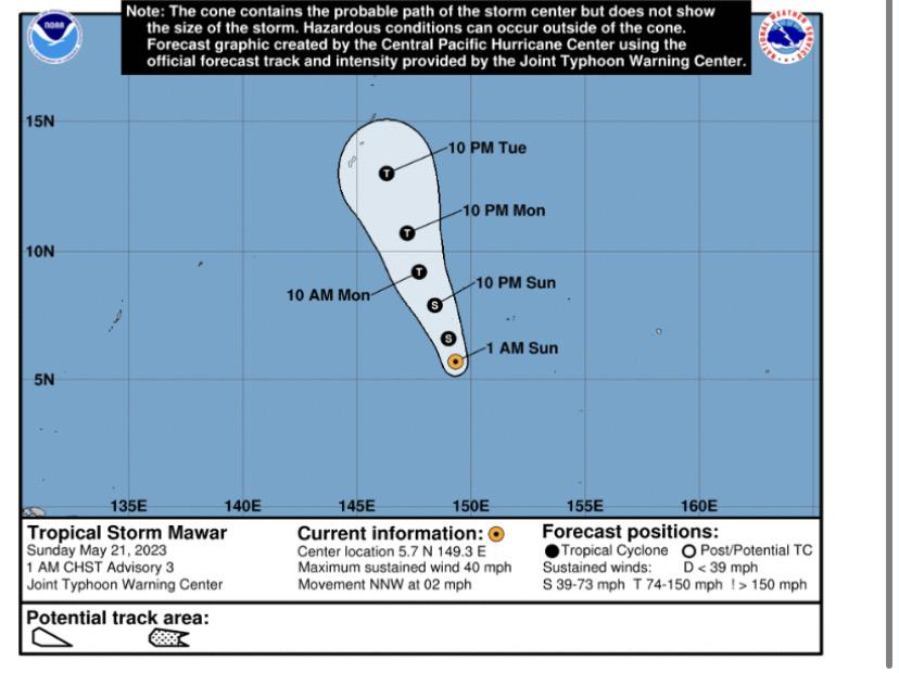
At 5:18 a.m., ChST, Sunday, May 21, 2023, the CNMI HSEM issued a statement providing that Mawar was located:
ABOUT 475 MILES SOUTH-SOUTHEAST OF GUAM
ABOUT 490 MILES SOUTH-SOUTHEAST OF ROTA
ABOUT 530 MILES SOUTH-SOUTHEAST OF TINIAN
ABOUT 535 MILES SOUTH-SOUTHEAST OF SAIPAN
Last night, CNMI Gov. Arnold Palacios placed the CNMI in Typhoon Condition III. Guam, which has a different public alert system, was placed in Condition of Readiness 3 earlier Saturday by Guam Gov. Lou Leon Guerrero.
More bulletins of information at higher frequencies are anticipated today and through the week, as Mawar approaches.
National Weather Service meteorologist Landon Aydlett in a briefing Saturday afternoon said this storm may miss the islands of the Marianas, or may be a direct hit to any of the four main islands (Saipan, Tinian, Rota, Guam). It still is too early to tell, though there is high confidence Mawar will intensify into a typhoon – and possibly at category 3 strength – and pass through the Marianas around Tuesday.
Mr. Aydlett emphasized these forecasts can change very quickly.
Both CNMI HSEM and Guam Homeland Security/Office of Civil Defense have been warning residents to use Saturday and today to prepare for the incoming storm by clearing their yards of objects that high winds can pick up, gassing their cars and tanks for generators, stocking up on emergency supplies and food, and more tips you can find at either of those agencies’s websites.


2 Comments
Bernadette
05/21/2023 at 8:36 AM
Thank you for the updates. I really appreciate it. Everyone stay safe.
Troy Torres
05/21/2023 at 11:00 AM
You’re most welcome. Please be safe.