A news release from the National Oceanic and Atmospheric Administration states weather experts believe Guam, Rota, Tinian, and Saipan may be hit by five to eight tropical cyclones this year, with three to five of those becoming typhoons as they reach the Mariana Islands. The outlook for the greater Micronesia region also shows increased storm activity in Palau, Yap, Chuuk, Pohnpei, and the Republic of the Marshall Islands.
Please see the NOAA news release below for further details:
The United States-Affiliated Pacific Islands (USAPI) of the FSM, the RMI, the CNMI and Guam will likely see above-normal tropical cyclone (TC) activity for the remainder of 2023, while TC activity across the ROP is anticipated to be normal to below normal for the remainder of 2023.
Above-normal activity is consistent with the recent shift to El Niño as supported by the latest National Weather Service (NWS) Climate Prediction Center (CPC) ENSO Diagnostics Discussion. This is likely to result in considerably more regional activity than seen in the past three years. An eastward shift in the TC genesis region is predicted to keep TC activity near or below normal at the ROP, with more TCs passing to the north. TC activity will vary considerably east to west and north to south due to the large extent of the Micronesia region.
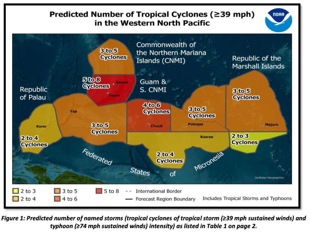
 This outlook is a general guide to the predicted, overall TC activity across the USAPI and does not indicate how many of these systems will actually make landfall. However, the outlook does provide a general idea of how many tropical storms and/or typhoons could affect a specific island or a group of islands across Micronesia, with peripheral effects such as strong damaging winds, torrential rainfall, and/or storm surge/inundation.
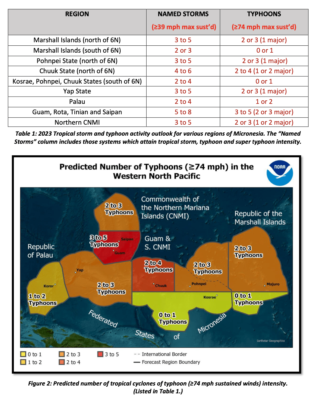
Although TC activity peaks around September-November for many regional locations, TCs can occur throughout the year across the western North Pacific. Therefore, there is no clearly defined ‘typhoon season’. TC activity can fluctuate greatly from year to year, though it only takes one to cause significant impacts. Therefore, we always urge residents, visitors and mariners to maintain preparedness for TCs year-round. Please visit the Guam Homeland Security/Office of Civil Defense, the CNMI Homeland Security and Emergency Management, and FEMA’s Ready.gov for more information on preparedness plans, tips and how to build emergency kits for use at home and at work.
The western North Pacific Ocean climate, and the factors that impact TC formation, typically change over a period of months. The International Research Institute for Climate and Society (IRI) at Columbia University, Palisades, New York and Climate Prediction Center (CPC) indicate El Niño conditions will continue to strengthen over the next several months. This outlook will be updated in August, if needed, to reflect any major changes to the current outlook.
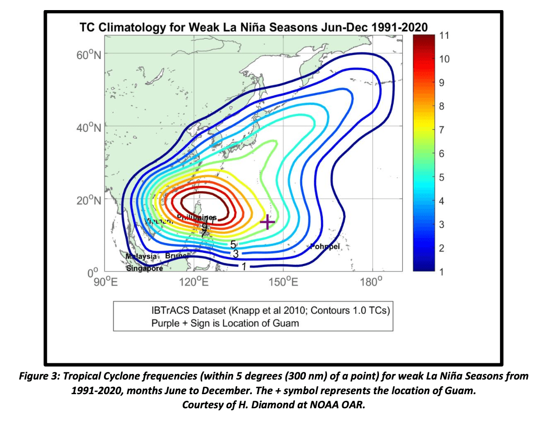
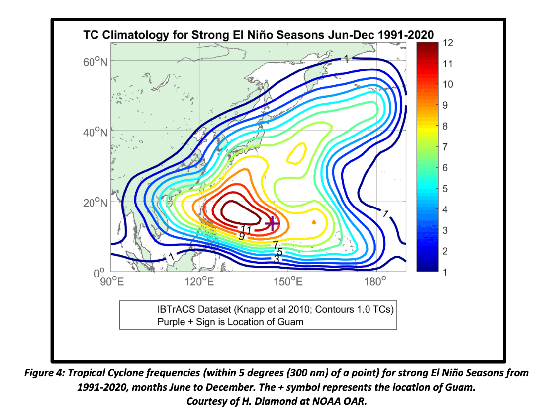
With 2023’s transition to an El Niño pattern, it’s important to understand the relationship of interannual variability of TC activity based on the ENSO phase. When looking at location-based TC frequencies, TC activity shifts eastward from the La Niña pattern (Figure 3) to the El Niño pattern (Figure 4). In contrast to the below-average TC activity across the USAPI region in the La Niña years of 2020, 2021, and 2022, we anticipate considerably more TC activity across the region due to the recent transition to El Niño and the possibility of its strengthening to a strong El Niño event by Fall.
The WFO Guam, in collaboration with the Joint Typhoon Warning Center (JTWC) and the Regional Specialized Meteorological Center (RSMC) Tokyo, Japan, continuously monitors weather conditions across the Marianas and Micronesia by using an array of observations, satellite data and output from complex numerical weather models that serve as the basis for TC track and intensity forecasts.
Follow us on Facebook and Twitter, @NWSGuam, and visit the WFO Guam web page at www.weather.gov/gum for updated weather information for Guam, the CNMI, Palau, the FSM and the Marshall Islands. The NWS provides weather, water and climate data, forecasts, warnings and impact- based decision support services for the protection of life and property and the enhancement of the national economy.
This outlook is a coordinated effort by NOAA’s NWS Weather Forecast Office Guam, the Climate Prediction Center (CPC), NOAAs Office of Oceanic and Atmospheric Research (OAR) Air Resources Laboratory, the NWS Pacific Region Headquarters in Pearl Harbor, HI, and Mr. Chip Guard of Tropical Weather Sciences.